Category Archives: Travels

pages fly away 9

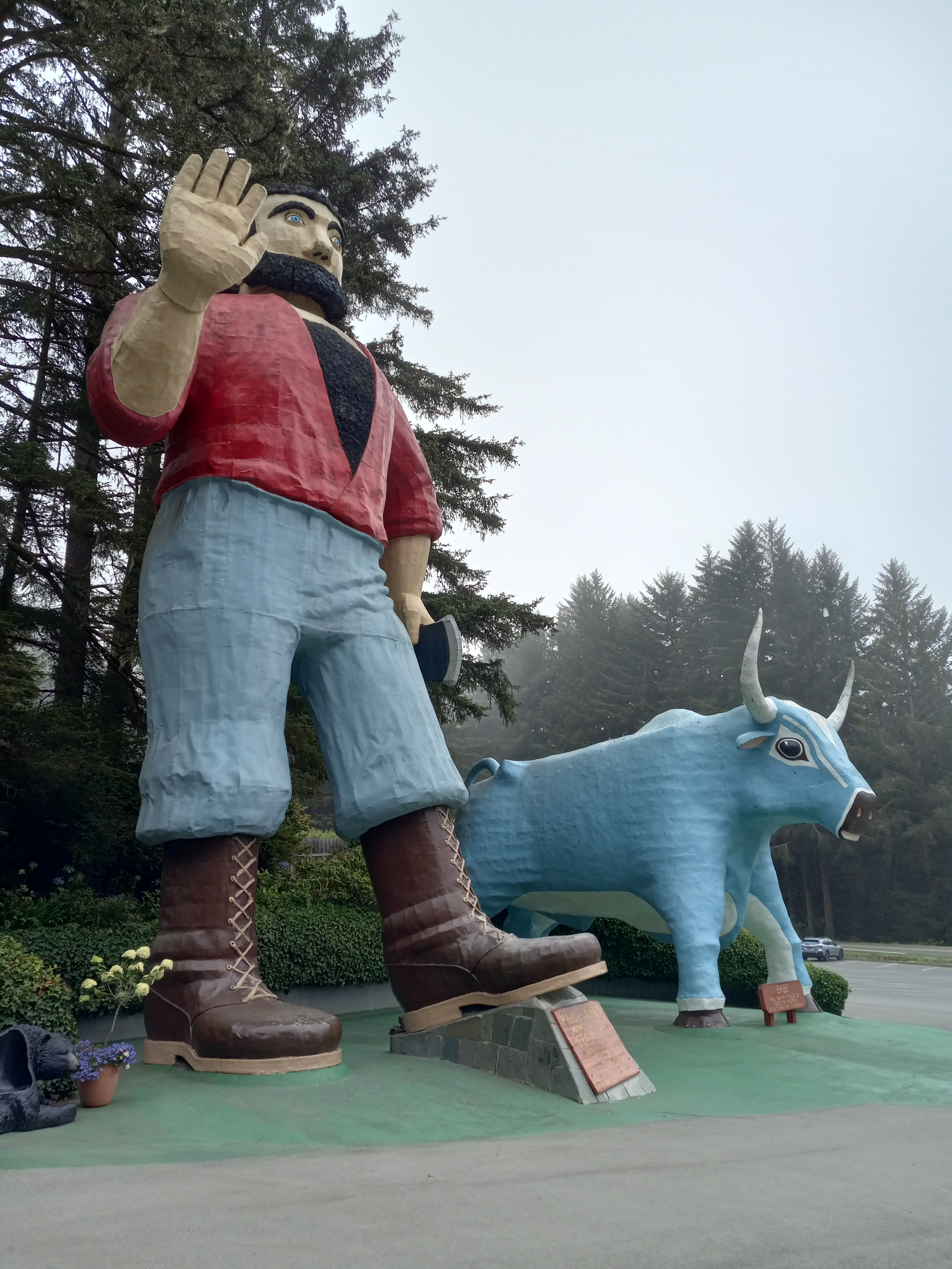
North of Arcata is a beach called Clam Beach where camping is allowed.  I’d camped there years earlier, and hoped they’d have a space for my tent.  To get there I got back on the 101 and crossed the Mad River.  There were a few sites around the parking lot and one of them was open.  I was three for three on the camping so far, and that had to happen if I was going to continue.  The fee was twenty dollars, which I could accept, being able to set up somewhere without the risk of being hassled.  What I couldn’t accept was paying a hundred dollars for a hotel, or sleeping in the car, not unless I really needed to.

After setting up the tent, I walked on wooden planks, through wetlands, to get to the beach.  There was still a quarter mile of packed, black sand to cross to reach the ocean.  The wind was blowing from the north, savagely and without reason.  Someone had balanced stones on top of each other that somehow hadn’t been toppled yet.  A young yoga warrior was sitting cross-legged on a dune, demonstrating his commitment.  Screw that.  The wind was out of control.  I’d brought along my ukelele but didn’t even consider getting it out.  Loose grains of sand were stinging my face.

That night some girls who were camped right next to me had a few cases of PBR and partied all night long.  They had a friend, Charlie, who joined them after getting off his shift at a bar.  They were loud but not obnoxious.  I couldn’t fault them for having their fun, but it was like trying to fall asleep in the middle of a party, right on the floor.  I’d done that many times, but not tonight.  One of the girls was complaining about her new roommate.  He’d offered to help with everything, but hadn’t, and then had eaten all her bananas without contributing one dime. 

Before six o’clock I was up, packing the car.  An older couple on the opposite side were breaking down their camp at the same time.  I wondered if they’d gotten any sleep.  It was only ten minutes to Trinidad, a fishing village on a bluff that I wanted to revisit.  There’s a lighthouse there that I thought might be a good place to meditate at, looking down on the harbor.  When I got there, it was gone, however, perhaps undergoing reconstruction, but the memorial to those who’d lost their lives at sea was still there.

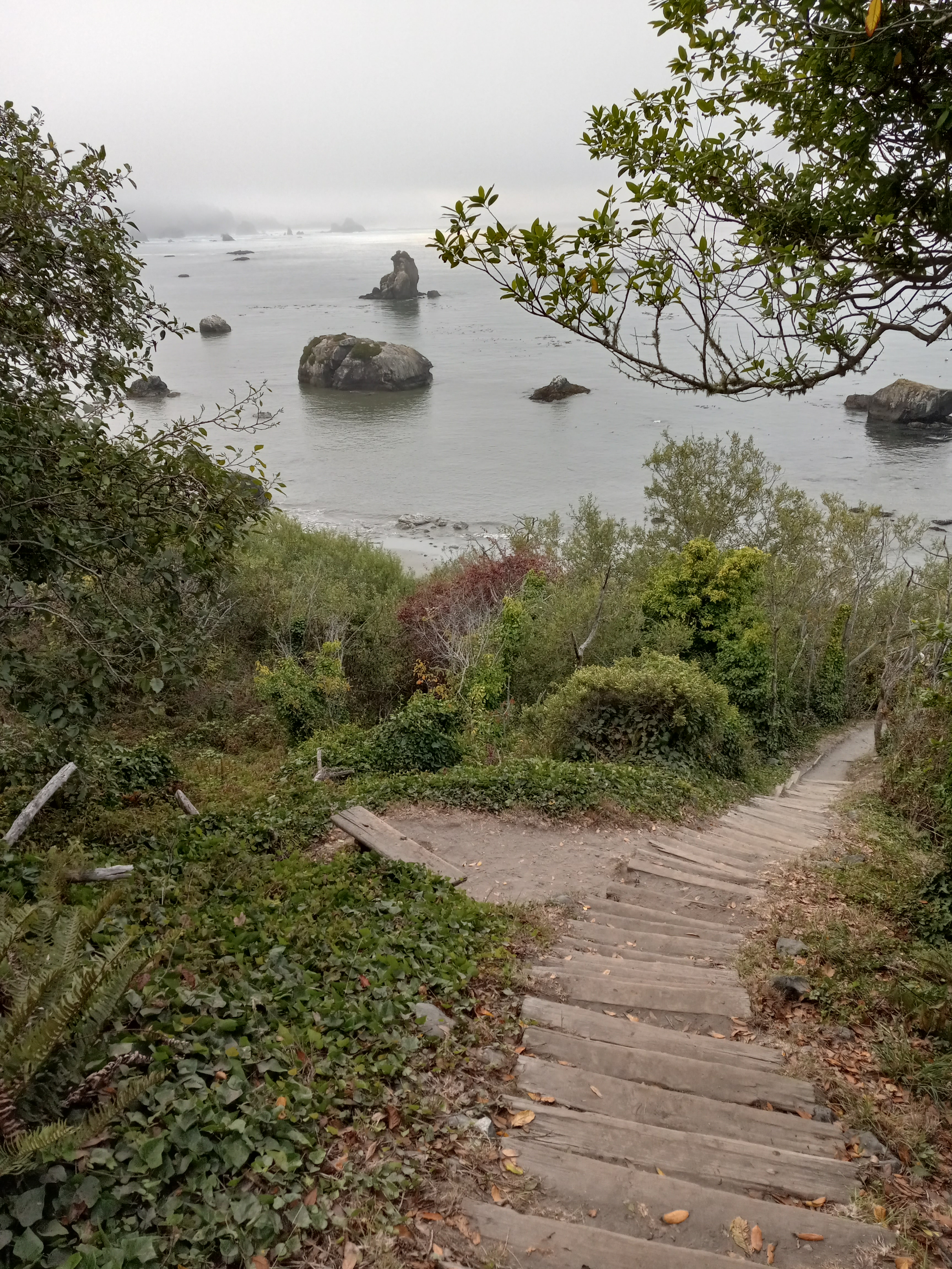
There were steps leading down to the sea and I decided to make a walking meditation out of it.  I’d spent time in a Buddhist monastery in Thailand and walking meditation is a recognized form of the practice.  Since I was nearly jumping out of my skin to hit the road, I decided then to implement it from time to time, if the conditions allowed for it.

I started to descend the stairs, step after deliberate step, measuring my breaths, making sure to draw each breath down to my navel.  A bell on a buoy was clanging out on the water.  Large, black rocks protruded from the water.  On a few of them, different seabirds sat huddled together, screeching at the waves.  There were a dozen boats anchored in the bay, a few miles from shore.  A crow started cawing.  There was the piping of some songbirds.

A cool breeze greeted me when I got closer to the water.  Thick bushes, looking like blackberry bushes without the berries, crowded both sides of the trail.  There was a bench I briefly sat on, thinking about my thinking, wondering where it was coming from.  Then I got up and started down the stairs again.  The closer I got to the ocean, the louder the waves crashed on the shore.  Small stones were tumbling in the surf.  The larger ones stayed resolute, like ancestors from a prehistoric age.  The beach was strewn with seaweed and footprints.  Driftwood lay cast around in various stages of decomposition.

I thought about those who had lost their lives at sea.  Then I thought about all of us, if not losing it at sea, losing it none the less, too often in far less dramatic settings, leaving this world unheralded.  If I’d ever made my peace with death, I wouldn’t be who I was.  Everything in my being recoiled at the thought of just vanishing one day, never to return, sinking into the black water, so far down, beyond hope of recovery.  I’d been constructing my own memorial my whole life, casting my lantern on the sea.  How would that work out in the end?  I couldn’t begin to know.

pages fly away 10

A tall tale is a story, perhaps once grounded in fact, that has been exaggerated beyond believability.  Famous characters from American folklore include Paul Bunyan, Pecos Bill, John Henry, and Davy Crocket.  They may have been real people at one point, but the stories that have sprung up around them and their adventures have made them larger than life, figures of myth and fiction.

On my road trip I’d already encountered one monument to Paul Bunyan in Three Rivers and was now on my way to reacquaint myself with Paul and his Blue Ox, Babe, at the Trees of Mystery, in Klamath, just forty-five minutes from Trinidad.  Along the way I stopped at Elk Country, but the usual herd of Roosevelt Elks was absent, leaving just a red barn and redwood sculptures of a cowboy, unsmiling Indian, and a totem pole to take pictures of.

Trees of Mystery, like Confusion Hill, is what people sometimes call a tourist trap.  It is interesting enough to justify a few hours there, however, with unusual trees like the Cathedral, the Candelabra, and the Elephant Tree, along with a canopy walking trail and gondola ride.  They also house a large collection of Native American artifacts, which was my primary reason for stopping by.  That, and to see Paul and Babe.

From the road the first sign of the Trees of Mystery, is the statue of the Indian, come to the end of the Trail of Tears, his head drooping, atop his hunched horse, his spear tucked under his arm, pointed at the ground in defeat.  Next to that is an American flag, which on this day was hanging lifeless from the pole.  I pulled into the parking lot and there were not more a dozen cars there.  A good day to just drop by. 

Paul stood there, fifty feet tall, black hair and beard, dressed in a red shirt over a black T-shirt, his jeans tucked into his logging boots.  Babe was right behind him at thirty-five feet, light blue and with great white horns.  Although capable of speaking and waving his right hand, Paul did neither, at least not to me.  Would I be able to separate it from just a delusion if he had?  I was riding high, not on anything but pure adrenaline.  Dreams, memories, and fantastic new realities were getting mixed up all over the place.

I went to use the bathroom, then entered the gift-shop and headed straight for the Native American museum.  One of the goals of the trip was to drive through as many reservations as possible, not to study them in depth, but at least learn a little about different tribes and where they’re located. 

Up until now when I thought about Indians what came to mind was the Hollywood stereotype, largely based on the Sioux and other Plains tribes, with the tipis, the feathered headdresses, the war paint, the peace pipes, the bows and arrows, the horses, and buffalo hunts.  I knew this was an incomplete picture but only had a small idea about the distribution of other tribes and nations, and what set them apart. 

There is a map on the wall of the museum with the traditional names and geographic locations of the tribes.  I bought a smaller version of, to act as some kind of guide.  The collection houses artifacts, largely from the western Regions of the US.  There were ivory fishhooks and totemic raven masks from the Northwest.  A wolf skin was mounted to the wall.  In one case there were black and white photos of Plains Indians, a warrior on horseback, a medicine man lifting his hands to the sky, a maiden by a stream, exposing one of her buttocks. 

There were many cases of Kachina dolls from the Southwest, representing spirits of the Hopi, wildly fantastic beings, a bear, a crow mother, a butterfly, a corn maiden, a striped clown, a buffalo warrior.  I looked at woven baskets, wooden flutes, a buckskin shirt with elaborate beadwork.  It got me all pumped up.  I was ready to explode.

Leaving the Trees of Mystery, I jumped into the Mountain Bluebird with no idea where I was heading.  North.  That was it.  Just north.  Would I continue up the coast?  I didn’t even know until I reached the 199 and veered off towards Grant’s Pass.  What was I doing now?  I was heading in the direction of Crater Lake.  There were some reservations north of that I could begin to visit.  I thought about heading back south as far as Mount Shasta, a sacred destination, in its own right, but perhaps that was too far. 

I just drove and kept driving on the Redwood Highway, jumping out to look down on the Smith River, deep blue and green, reflecting the pines, yet at the same time nearly transparent.  Someone had left a little birdhouse beside the road.

Driving through the Cascade-Siskiyou National Forest, I almost had the highway to myself.  I was flying through the mountains, leaning hard into the curves.  Outside of that one spot of rain in Yuba City, the weather had been perfect so far.  At Grants Pass, I got on the 5, heading towards Mount Shasta, but just past Ashland, got on the 56 and headed towards Klamath Falls instead. 

It occurred to me that might be a good place to stop and set up camp, but when I arrived in Klamath Falls it was still too early in the day.  I had to use the bathroom so pulled into Moore Park besides the Upper Klamath Lake, and right up in front of a porta-potty, just as a homeless woman was stepping out.  Inside it resembled a crime scene.

Wanting to get closer to Crater Lake, I searched for a campground on Google Maps, and let the woman, the voice that I was becoming familiar with and beginning to trust, lead me onto the 97 in the direction of the Happy Trails Cowboy Campground, only thirty miles away.  As I was driving north, however, I saw an enormous amount of fire damage.  The earth had been scorched black in some areas and the campground was subsequently closed.  Continuing on, I passed another one, but it was only for campers and mobile homes.

It was late afternoon by now, and I was starting to get a bit worried, knowing that without a reservation, I wouldn’t be able to camp at Crater Lake National Park.  Maybe I could’ve figured it out on my phone, but resented what they were doing, adding a surcharge on top of a charge, making something very simple into something enormously complicated and expensive. 

Outside of Fort Klamath, I passed a campground that looked like it might just be for RVs but decided to ask anyway.  They did have a few tent sites, but each cost fifty dollars.  It was the first big money hit of the trip, but I decided to deal with it.  It was a beautiful campground, built around a shallow, gurgling stream, and the site I paid for was beneath a tree on an enormous bed of green grass.

After I set up the tent and laid down my bedding, I went and walked beside the stream, which was reflecting every color in nature, the most perfect meditation spot, but not tonight.  My mind was jumping.  There was a store inside where I bought a few hardboiled eggs and a Slim Jim.  The guy working the counter was a college student who was supposed to be studying in Australia until the pandemic messed it all up.  He’d taken a philosophic approach to the whole ordeal and was easy to talk to.

It got cold that night.  I got under the sleeping bag and both my blankets, but my mind kept jumping.  I could see the road ahead.  The way that the trip was already unfolding, told me it was going to be epic.  I’d barely scratched the surface.  Awake, but content, I lay there and schemed, right up until I fell asleep and started to dream.

pages fly away 11

Crater Lake is a volcanic lake, and at nearly two thousand feet, the deepest one in America.  The Klamath tribe believed that a battle between the Sky God and the Lord of the Underworld led to the collapse of Mount Mazama and the formation of the lake.  It is considered to be the adobe of the Great Spirit and is a prime destination for those embarking on a vision quest, full of danger and great beauty, capable of shocking one into awareness.

The park was open when I arrived at the crack of dawn.  I may have been the first visitor of the day.  I parked outside Rim Village, hoping to get a cup of coffee, but the store was still closed.  I drove over to the side of the lake and got out of the car.  The sun was just beginning to rise over the rim of the crater.  It was cold enough to keep my hood up and my hands inside my pockets.

The water in Crater Lake is known to be bluer than blue, like the blue Kia, the Mountain Bluebird, that I’d rented for the journey.  The sky was blue.  The lake was blue.  The day was already a triumph of blue.  Below I could see the cinder cone, known as Wizard Island.  There were pine branches overhead, and pine trees beneath me.  The white all-seeing eye of the sun continued its ascent.  I sat on a stump and tried to meditate, or at least just stay in the moment.

There was hardly a sound.  A few birds.  My fingers and toes were numb with cold.  Before long, they begin to warm.  The sun was growing larger, starting to radiate and expand.  A drowsy fly came to life and began to buzz around my face.  Is that one of the constants of meditation?  That a fly has to buzz around your face and try to get up your nose?  I heard the swish of car tires behind me.  Then another and another.  I was no longer alone in the park, nor was I alone in my mind.  I resented the car full of tourists who parked nearby and got out with noisy voices.  Were they trying to ruin my good thing?  If not for them, and the fly, and all of my thoughts, I could probably get into the zone.  This was definitely the place to do it.

Though I was mediating, I didn’t want to broadcast that fact, like the guy at Clam Beach, by wrangling my limbs into a cross-legged lotus, nor would I pinch my thumbs and forefingers together and rest them on my knees in a receptive mudra position.  If anything, I wanted to make it look like I was just sitting there resting, possibly thinking, because that’s about all I was doing, sitting there thinking, about the fly and the voices I could hear, where’d I’d drive to next, where I’d stop for the night.  What could I see that afternoon?  No.  No.  I had to pull myself back and begin to count all over.  Wasn’t just being there better than anything?

After getting back on the road, I stopped at a few viewpoints, most notably The Watchman, which provided a different view of the lake.   There were many tourists in the parking lot, all strangers in real life, humbled by the power of nature, observing a temporary cease-fire, interacting with courtesy and respect, as long as the moment lasted. 

I got back in the car and got on the 97, racing north towards the Warm Springs Indian Reservation, which looked to be three hours away, passing through La Pine and Bend along the way.  At Madras, I got onto the 26.  It was just fifteen miles from there.

My greatest fear was that a majority, or even some of the reservations, would be closed to outsiders because of the pandemic.  The worst of it may have passed, but many places were still being extra careful.  I had a mask in my pocket and sometimes put it on, depending on where I was at.  It would’ve sucked, but not surprised me at all, if I’d pulled up at Warm Springs and couldn’t get in. 

Instead, the only thing impeding my progress was a major construction job on the road leading into the agency, where cars were lined up in each direction, waiting for a pickup truck to guide them through.  That I could deal with.  At least they were still letting people in.

pages fly away 12

The Confederated Tribes of Warm Springs is made up of three tribes: the Wasco, the Tenino, and the Paiute.  They are some of the last to speak the Chinook Jargon, a pidgin trade language that originated in the Pacific Northwest.  Historically, their economy has been heavily dependent on fishing, but Iin 1964, a resort was completed, and in 2012, the Indian Head Casino was opened, with five hundred slot machines. 

I didn’t really know what I was doing there, just poking around more than anything.  I wasn’t about to drive around with a dream catcher dangling from my rearview mirror, trying to crash ceremonies.  If invited, I’d do anything.  If not, I’d try to remain unobtrusive.

High upon a dry hill, beneath three tipis, was the name Warm Springs.  I drove into town, past the tribal headquarters and community center.  A restaurant in a trailer was selling Indian Fry Bread.  A sign advertised an upcoming suicide awareness walk.  There were some murals outside the Warm Springs Market, one of an elder, a woman, in a traditional basket hat and glasses.  There was another of a younger woman, wearing the same style hat and a jingle dress, clutching a flowered bag in front of her.  Then there was a hoop dancer, in a green shirt and headband, keeping five hoops aloft on his outstretched arms.

The hoop dance is popular with many tribes across the states, performed both in competitions and for healing.  The story is that a magical boy invented the dance, using the hoops to mimic animals and tell the stories of humankind.  Later, drums and flute were added, and the modern incarnation, created by Tony White Cloud in the 1930s, went on to incorporate multiple hoops, sometimes as many as twenty-eight at one time.

On another side of the market, there was a larger mural, that of a young man holding a frame drum, turning to face the distant snowcapped mountains.  All around him life was abounding, a salmon was leaping from a stream, two mule deer stood beside it, a bald eagle hovered overhead, a coyote snuck through the tall grass, two wild horses danced in the wind.  This is a vision of what life could be, not what it had become.

From the town of Warm Springs, I drove up to the northwest corner of the reservation and got on to highway 35, right at the base of Mount Hood.  Mount Hood is the highest peak in Oregon, with twelve glaciers and snow year-round.  A road crew was painting new yellow stripes down the center of the road, and I noticed it just in time and stayed far right.  Returning the Kia with yellow tires, along with all the mileage I was already racking up, would be hard to explain.

It wasn’t far from there to the Colombia River.  When I reached the town of Hood River, I got on the 84 west and went down to Cascade Locks, a system of canals and gates once used to navigate the dangerous rapids, and parked beside the Bridge of the Gods.  It was late afternoon by now and time to find a campsite.  Google Maps directed me back in the direction I’d just come, to a place called Wyeth Campground.  The owner was walking around with a clipboard when I pulled in and directed me to an open spot.  I set up my camp and then took a long walk to get my bearings and stretch my legs.

It had been a long day and I was exhausted, yet a tight wire of adrenaline was still buzzing in my brain.  I got in my tent early that night and waited for the sun to rise, tossing back and forth, and listening to the wind blow through the trees.  The only other sound was the pounding of my heart.

pages fly away 13

In the morning I followed the road over a bridge that crossed the highway.  On the other side, approaching the Colombia River, was a sign stating that the fishing rights belonged to members of the Nez Perce, Umatilla, Warm Springs, and Yakama tribes.  Further down the road was a fishing camp.  There was a red salmon painted on the side of a shack and a few men were working on a boat.  I cut straight over to the river and sat down on the bank.  It was another perfect day.  How many in a row had that been?

I found a fallen log with small, black stones scattered around it.  A clearing in the branches made a natural window.  I sat down and rested my hands on my knees.  The river splashed across the stones.  Cars went whirring past on the highway.  I could hear muffled voices from the fishing camp.  I closed my eyes and thought about the river.  I opened my eyes then shut them again, and it continued to dance across my eyelids.  Splashes of sunlight worked their way through my brain.

The Colombia River begins in the Canadian Rockies and runs 1,200 miles through seven states.  At one time it played host to the greatest salmon run on earth, but now, with nineteen hydroelectric dams on it, providing water and power to many, far less breeding salmon are able to return. The river still runs powerful and deep, however, and remains a force not to be trifled with.  The energy of it was apparent from where I sat.  Its great presence stirred something inside me, beyond the wild channels of imagination that were opening in my mind.  It moved my spirit.

When I opened my eyes, it felt like I’d been gone for a long time.  Walking back to camp, I came across some blackberry bushes.  They were loaded with ripe berries, almost enough to make a breakfast of.  I picked and ate them until my fingertips were stained purple.  A little further and I crossed some railroad tracks, gleaming in the sun. 

After breaking camp, I got on the 84 and headed east, only traveling thirty miles before pulling over to visit the Dalles.  The Dalles was once a major trading place for Native Americans.  Lewis and Clark passed through there in 1805, hoping to reach the Pacific Ocean. 

It was at the Lewis and Clark Festival Park that I pulled into, getting out and walking to a steamboat at the river’s edge.  It was named The American Pride. A few old women in period costumes, flapper dresses and glittering hats, were greeting passengers and passing out brochures.  A crew member confided in me that the cruise cost a thousand dollars a day.

A mural on the wall of the park called Sahaptin Medicine Man showed four pictures of the same shaman, in the first waving an eagle feather towards the river, in the second sitting cross-legged and playing a frame drum with his eyes closed, in the third tending to a small fire, and in the fourth, pulling salmon from rapids as they leapt upstream and drying them on a rack.  The medicine man lived away from the tribe and tended to matters of the body and spirit.  He was able to speak for the land and see renewal in all things.

The Dalles is the seat of Wasco County.  As I drove through the small downtown, I came across other murals commemorating the history of the region.  There were settlers on the Oregon Trail with their covered wagons and oxen, mountain men and trappers paddling canoes.  Another showed Natives, spearing fish out of the river, trading goods in baskets, and standing beside their horses.  A ghost sign, painted on a brick wall, advertised flapjacks.  Right next to it was a giant wagon wheel. 

A painting called Rock of Ages showed a preacher standing high on a rock, preaching to a congregation of Native Americans.  There is a lot they would come to know about the White Man’s Book of Heaven.  This new medicine came with side effects that were worse than any disease.  The medicine man had no power to cure them.  The time of troubles was just getting started.

pages fly away 14

From the Dalles, I took the 84 east to the 97, and traveled north towards the Yakama Reservation.  The Confederated Tribes and Bands of the Yakama People is made up of seven tribes and occupies two-thousand square miles in Southern Washington, bordering the Cascade Mountains. 

The first city I came to after entering the reservation was Toppenish, known as the City of Murals.  The meaning behind that name was soon evident, but first I stopped at the visitor center.  The attendant there was friendly enough, retired from the highway patrol, and invited me to use the bathroom without my even asking.  I learned that the first mural was completed in 1989, intended to correspond to the state centennial, and that since that time seventy-eight more murals had been added.  If a town wants to draw attention, I can’t think of a better way to do it. 

Toppenish was full of history and art, a crash course in all things related to the Wild West.  One side of a building showed a group of long-horned cattle being driven down an unpaved main street by a few cowboys, past a Drugs and Sundries shop, and a young man reigning in two horses attached to a wagon.  Another depicted a cowboy in a rodeo, busting through the wall on his horse, waving a lasso over his head, on the heels of a frantic steer. 

According to the Treaty of 1855, fourteen tribes ceded eleven million acres to the United States.  In a mural depicting the meeting of the governor of Indian Affairs, Isaac I. Stevens, and the Yakama chief, Kamaiakun, an American flag stands next to an Indian spear, with calvary troops riding in one direction, and Native warriors riding in the other.  It appears as if an equitable agreement had been reached and both parties are departing in peace.

Not far from there was a marker indicating where Captain A.J. Hembree was killed by Indians in 1856.  Hembree was a volunteer from Oregon, who was shot in the gut during a skirmish with the Yakama.  Apparently, the other volunteers fled and Hembree was able to hold off his attackers a while longer, but finally he was killed and scalped.  His body was taken back to Oregon to be buried.

Walking further, I stopped outside the Post Office and read about the early days of mail delivery.  Apparently, in those days the postman had to supply his own horse and buggy and the route was twenty-three miles long.  He had to travel over rough roads and ford streams to get the mail delivered, and that’s when the weather was good.  In the wintertime, he was lucky not to freeze to death.

A few blocks later, I stopped outside the Yakama Nation Victim Resource Program.  The painted windows showed a powerful Thunderbird, a loving couple, and a happy balanced family, standing outside a tipi.  It seemed to be their mission statement.  Then I went over to read about Alex McCoy, from the Wishram and Wasco tribes, who became a cowboy and went on to invent bulldogging, a rodeo sport in which a steer is wrestled to the ground.  In the years that followed, he became a shaman and judge, and lived to be a hundred and four.

One mural with a caption told of Irish Dick, a sheepherder who once traded a bear cub for whiskey.  Upon his return to town, the now fully grown bear escaped from its chains and a tussle between the two of them ensued on Main Street.  Eventually, the bear was returned to the saloon and Irish Dick was taken to the hospital. 

There was a shop window with black and white photos of tribespeople in their ceremonial clothes, a group of women and girls in beaded dresses and headbands, a chief in full feathered headdress, a necklace of bear claws draped around his neck, holding a rifle at his side, other leaders in headdresses led a procession of horses down the street.  It was like I’d been transported back in time.

On my way out of town, I stopped at a 7-Eleven.  There were even murals outside of that, dancers demonstrating the Prairie Chicken Dance and the Owl Dance.  I got a hotdog and soft drink and pulled over at Pioneer Park to eat.  There I saw a news crew setting up.  They interviewed a man who came stumbling towards them with a bandana covering most of his face and a COVID mask covering the rest.  He was also wearing sunglasses, so it was almost like they were interviewing the Invisible Man. 

Maybe that’s how it felt to be landlocked in such a rich country, stripped of his way of life, and sleeping in the park.  And what about that COVID?  What would they think of next?

pages fly away 15

It was only three hours to my next destination, the Colville Reservation, but already late afternoon by the time I left Toppenish.  I opted to take the 97, a small country road that wandered through the mountains, and paid for it by getting stuck behind an RV that was pulling a whole train of us behind it, all of us maxed out at forty-five miles an hour, unable to pass because of the curves and hills. 

Then I took the got on the 2, driving through Entiat and Chelan, and stopped for gas in Brewster.  I wanted to drive across the reservation, so went as far north as Omak where I picked up the 155 heading east.

The Colville Reservation is nearly three million acres, and twelve tribes make up the confederated tribes that live on the land.  Like many of the Natives of the region, they lived a semi-nomadic existence before the arrival of the Europeans and Americans, migrating according to the seasons and cycles of nature.  They got fish from the rivers.  They gathered berries and hunted deer on the plateau.  They went where they needed to and did what they had to do to survive.

Of the twelve tribes, the one group of outsiders was always the Nez Pearce who followed Chief Joseph.  Originally from Wallowa Valley in Oregon, they were forced onto a reservation in Idaho that they fled from in 1877.  Their hope was to join Sitting Bull in Canada, and they nearly made it, traveling 1,170 miles, all the while fighting off the U.S. Army, which was in hot pursuit. 

Finally, only forty miles from the border, his people starving and freezing, Chief Joseph was forced to surrender.  He did so on the condition that they be allowed to return to Idaho.  Instead, they were shuffled from reservation to reservation, and finally ended up at the Coleville Reservation, having little in common with the tribes already there. 

Nowadays, Chief Joseph is seen as a hero of the Indian Wars, admired for the resistance and ingenuity he and his followers displayed in the face of overwhelming force, as well as for his humanity and eloquence.  He spoke honestly in defeat about not only his sorrow and loss, but also the need for there to be equality among all men.

Driving south on the 155, I passed Nespelem, where Chief Joseph is buried, and a rest area serves as a monument.  There is a metal sculpture of him, balancing a peace pipe in his hand, as well as other sculptures, a warbonnet, a warrior on horseback, a woman behind, also on horseback, dragging a travois with a child perched on top.  A plaque outside the bathrooms tells the story of Chief Joseph and his tribe.

My goal that day was to make it to the Grand Coulee Dam, and it was already nearing sunset by the time I did.  As had become customary, I was leaving everything to chance, hoping another campsite would roll into view once I needed it.  By now, there were three of us on the journey, myself, the rental car I’d dubbed the Mountain Bluebird, and the woman from Google Maps.  I’d checked to see if she had a name, and discovered it was Karen.  Karen it was then. 

Google Maps located a campsite on the other side of the dam called the Spring Canyon Campground.  I never would’ve found it on my own.  There were no signs, nothing in my book of maps to indicate a campground anywhere in the vicinity.  I pressed start and Karen began to guide me there.  I followed River Drive and crossed the Grand Coulee Bridge.  From there I took a left on the 155 and passed the visitor center, making another left on Grand Coulee Avenue, past hotels, an RV park, and churches.  There was a long driveway to the campground that passed a cemetery.  By the time I arrived, it was rapidly growing dark.

There were plenty of open spaces.  That came as a relief.  When I went to pay, however, I discovered that reservations were required, and they didn’t accept cash.  Good God.  What a hassle.  I had two choices, either to pack it up and move on, or to stick it out and try to explain the situation if a ranger showed up. 

I went with the latter but couldn’t rest easy that night.  There were deer and quail right outside the door, but a fear had been planted in my mind.  I was going to get busted, maybe get a fine or get kicked out in the middle of the night.  Every time I heard a noise, I stiffened.  Then the wind picked up and I was the only thing weighing my tent down.  Finally, I just crashed out of exhaustion.  The plan was to sneak out before the first light of dawn.